9. BUT WHERE DOES IT COME FROM?
While this glacial erratic comes from the north, I had assumed that pinpointing the precise origin of the stone on a map would be impossible, but I’ve spent the past two months reading articles and corresponding with geologists, glaciologists, and geographers, trying to sort out the steps I need to take in order to get as close as possible to the parent stone in the Canadian Shield where my erratic broke off before moving south.
This phase started about two months ago when I was corresponding with Peter G Knight, Reader in Geography at Keele University and author of the clearest book on human interaction with glaciers in art and culture, and Peter asked me if I knew where this stone came from. Knowing the vastness of the Canadian Shield, I hadn't even considered that it might be possible to identify the parent bedrock until that moment. Peter mentioned that the lithology of the erratics in central England is specific enough that they can identify the outcrop that an erratic came from, and that this helps confirm the direction of the flow of the glacial ice which has long since melted away. I didn’t know if this would be possible, but I knew I needed to start talking to researchers closer to home, and Peter pointed me to Broster, Munn, and Pronk, 1997 outlining research findings from fieldwork in New Brunswick that traced past ice flow directionality by drawing inferences from the dispersal of clasts (a.k.a., erratics) in glacial till.
New Brunswick had a glacial experience that was significantly different from that of the Great Lakes region, the ice sheets over the Great Lakes were thick, in some places 3.2km, but the edges of the ice sheet were much thinner, which means that stones didn’t move as far in New Brunswick as they did in what is now the Great Lakes region. In fact, Broster et al., indicate very short train lengths for the conveyance of glacial materials, generally between 4km and 10km, but in cases where clasts have moved higher into the ice (instead of sitting underneath the glacier), ice-streaming took place that enabled stones to move as far as 26km. Terrain and geography could impact the location of a stone in a glacier, and if the glacier would sheer, say after sliding over a hill and breaking, the ice with the stone could transpose to a higher location in the pile of ice that accumulated at the bottom of the hill or cliffside. If the stone was higher in the body of ice, then that means it had more time to ride the glacier which could enable it to move much farther. So I asked Broster what he thought about distances and if it was possible for a stone to move upwards high enough to enable it to move from the Canadian Shield into Ohio, or if it would be more likely that successive re-sedimentation would have been what enabled my stone to move farther than 26km. He told me that the Great Lakes region is different, and that based on his work across Canada “‘glacial – transported’ boulders can be transported hundreds of miles (many hundreds of miles).”
I asked about re-sedimentation because over the past decade I’ve collected a number of glacial erratics in a farm field in Huron County, Ohio in a location south of where I found this granite erratic, and some of them ended up in this field because of re-sedimentation. This part of Ohio is flat because the surface is a terminal ground moraine made up of a thick layer of glacial till, and since flat land is great for farming, this glacial till is constantly being plowed over. Not to mention uplift, the phenomena where heavier materials rise to the surface. If you buy blueberries in a plastic clamshell container, then you’ve seen this happen because the larger blueberries always make their way to the top of the container while the smaller ones fall to the bottom. It’s a packing problem, and it also happens where different soil layers touch, so glacial erratics sitting in till from earlier glaciation can make their way into the layer of till from a more recent glaciation, eventually finding the surface, and occasionally being struck by a plow, like this specimen which I found in the farm field after it had been shattered into at least these 97 pieces I picked up:
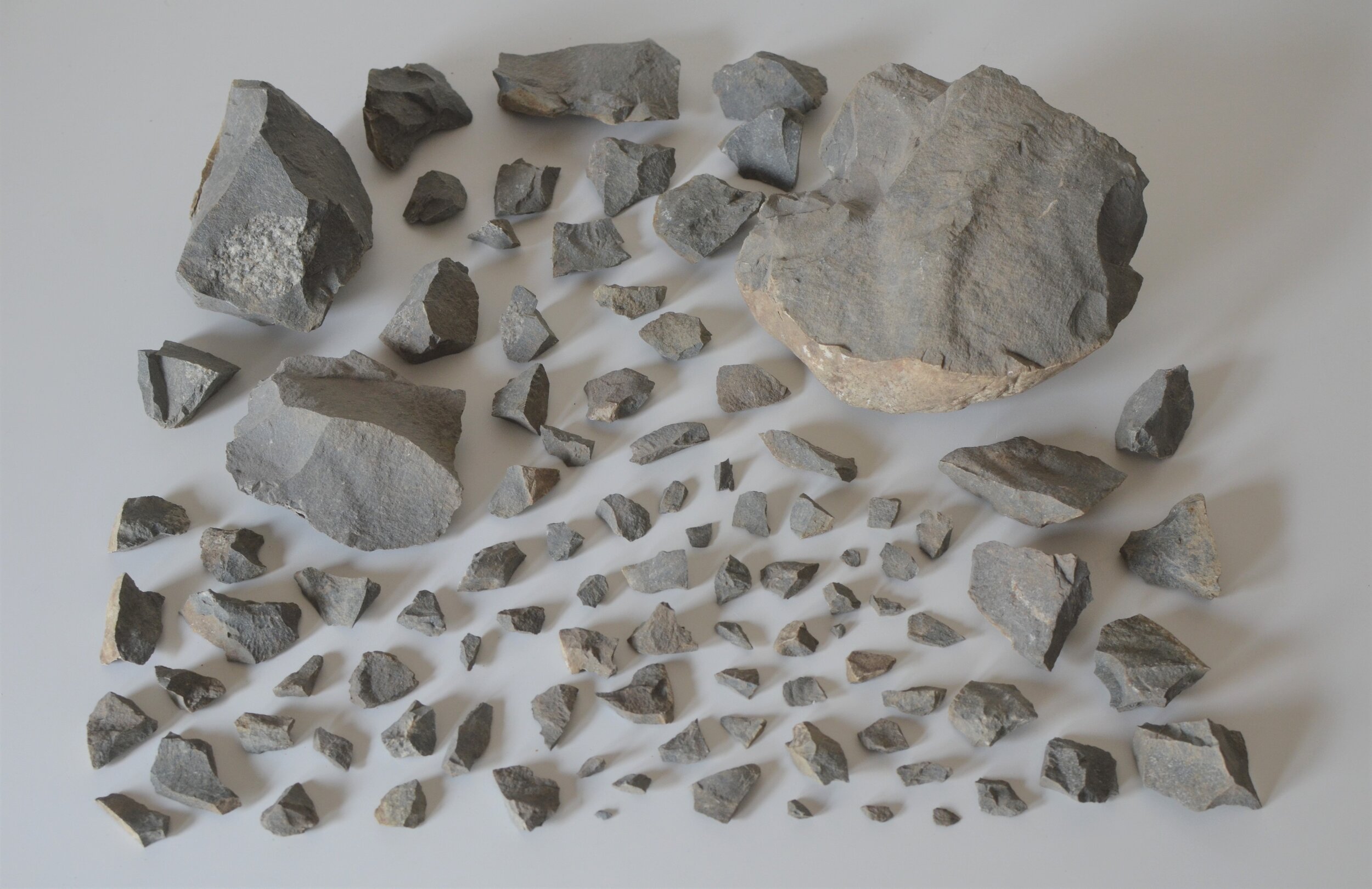
This is a piece of Gowganda Tillite, a sort of fossil of a moment in an earlier glaciation in what is now Ontario. It’s actually glacial till that has been turned to stone in the same ways that other sediments undergo lithification to form horizons of shale, mudstone, siltstone; the pressure that comes from burial and layering eventually make mud into stone. So here is till from an old glacier, turned into stone, and now moved by a new glacier. It comes from the Gowganda Formation in the Huronian Subgroup, a trace of the Huronian Glaciation that occurred 2.4 billion years ago (Gya) alongside the Great Oxygenation Event responsible for the abundance of oxygen that made it possible for life to thrive. This piece of stone is at least 2 billion years old, but what is inside that stone is much older. Inside this tillite (a sedimentary stone) is an embedded igneous stone, and that igneous stone is well rounded indicating that it had been broken off from its parent bedrock and tumbled smooth by mechanical force. Since the tillite was glacial till, it is likely that the same glacier which moved the soft till had also been tumbling this hard igneous diorite cobble in the same mix. It’s also likely that the diorite is a dropstone, which according to this paper from the Ohio Department of Natural Resources states “occur when a sheet of ice or iceberg floating in a lake melts, and the heavy pebbles or cobbles sink into the lake bottom sediments” The lake in this case is a glacial lake at the front of a receding glacier in the meltwater, and the diorite might have been a piece of rock that had been transposed higher into the ice, only to be calved off into the glacial meltwater before dropping down into the milky glacial sediments at the bottom of the puddle. And this puddle happened to form 450 miles directly north of the farm field where I found this specimen. This glacial clay that is 2.4 million years old made its way 450 miles south to Ohio, but it didn’t necessarily happen in one go…this is where re-sedimentation comes into play. It is also very likely that it was slowly moved by many glaciations. But the fact remains, south of where I found my granite erratic (which presumably moved only a short 20000 years ago), there is also lithified glacial clay that is evidence of glaciation that took place 2400000000 years ago.

This is the field where I found the Gowganda Tillite. Sources: Esri, DigitalGlobe, GeoEye, i-cubed, USDA FSA, USGS, AEX, Getmapping, Aerogrid, IGN, IGP, swisstopo, and the GIS User Community
According to Broster, Gowganda Tillite is only one of several indicators that glacial boulders moved from Northern Ontario into Ohio, and that taken together we can know that while the stones were picked up at different points along the way (i.e., not of the same origin), we know that they traveled along the same path. So at this point, I’m sticking with my assumption that this granite erratic moved south from the Canadian Shield.
When I asked about pinpointing the granite parent rock formation, Broster’s only guidance was to look at the zircon and other minerals that are resistant to get a finite date of origin which would relate to a particular part of the Canadian Shield. So I started asking geology departments at research universities and research departments of natural history museums close to home if they could help, and my first stop was Case Western Reserve University (where I earned my MA, and where I served two appointments as a visiting researcher in cognitive science). I’m always upfront with people that I’m not a geologist, and sometimes that makes starting conversations difficult and I had to write a couple of times before I got a response and then my question was passed around before I got responses like “exploring the parentage of glacial erratics is a really difficult business and rarely done nowadays” and “the overall research value of the work is low by modern standards (they can be used as tracers of glacial movement, but those are problems nearly all consider "solved" a long time ago” and “Even when they're something visibly interesting…, the academic level of interest barely rises above "satisfy my curiosity". So the likelihood of finding someone who can say "that's from the Kirkland lakes tonalite plutons" or similar is very low.” I took these answers with a grain of salt, these responses aren’t actually as dismissive as they sound, some of the responses are filters, but others are just plain facts presented in uncluttered language. I knew I needed to be precise, so I started asking specific questions about mineral composition. I started talking with Ralph Harvey who teaches mineralogy at Case, and he mentioned that it would not be possible to distinguish between the plutons in the Canadian Shield without analysis at the isotope level.
At this point, I’m not interested in destructive methods for analysis so I wondered if traditional basic techniques from geologic classification would help, characteristics of crystal structure and mineral composition should be useful in identifying a rock specimen, and I mentioned that because my sample was phaneritic, I would be able to measure the sizes of the crystal grains as a starting point, then confirm mineral by looking at the crystal structures and Mohs hardness for each crystal, then factor in the percentage composition of the major components, take their specific gravity and calculate the estimated weight for each type of mineral, which I could then use as a proof for component identification by taking the calculated crystal weight total and matching it to the actual total weight of the stone itself. I realize there is a lot of room for error at each of those leaps in interpretation and measurement, but I wondered if in terms of a first attempt outside of isotopic analysis if that would get me anywhere.
Ralph’s response was that “igneous rock from totally different places can be astonishingly similar” and that without isotope analysis, simple petrology wouldn’t help narrow down the region of Canada, but even with the isotope data, I’ll still need to get lucky because someone would have had to already gather the isotope data for the parent pluton and published it somewhere.
I need to find another way to leverage data, but first I need to get some positive identification on the minerals in my stone. I think there might be other data besides isotope data that can help pinpoint this answer though. Let’s say my stone happens to have a significant percentage of a particular mineral, and I’m able to find plutons in the Canadian Shield that tend toward presenting a higher percentage of that particular mineral (say by correlating the ph of that higher percentage mineral with vegetation patterns as markers - which if you don’t know, soil ph is a major determining factor for what types of plants grow and where). Then this vegetation data should help define possible zones for investigation of those sections of the Canadian Shield. Currently, I’m using the ecological land units base map in arcGIS which was derived from data repositories of bioclimates, landforms, lithology and land cover, and I’m wondering if I can use that data (which already has gross parsing of vegetation), that it could help eliminate the places I shouldn’t look. Here’s a screenshot of my map:
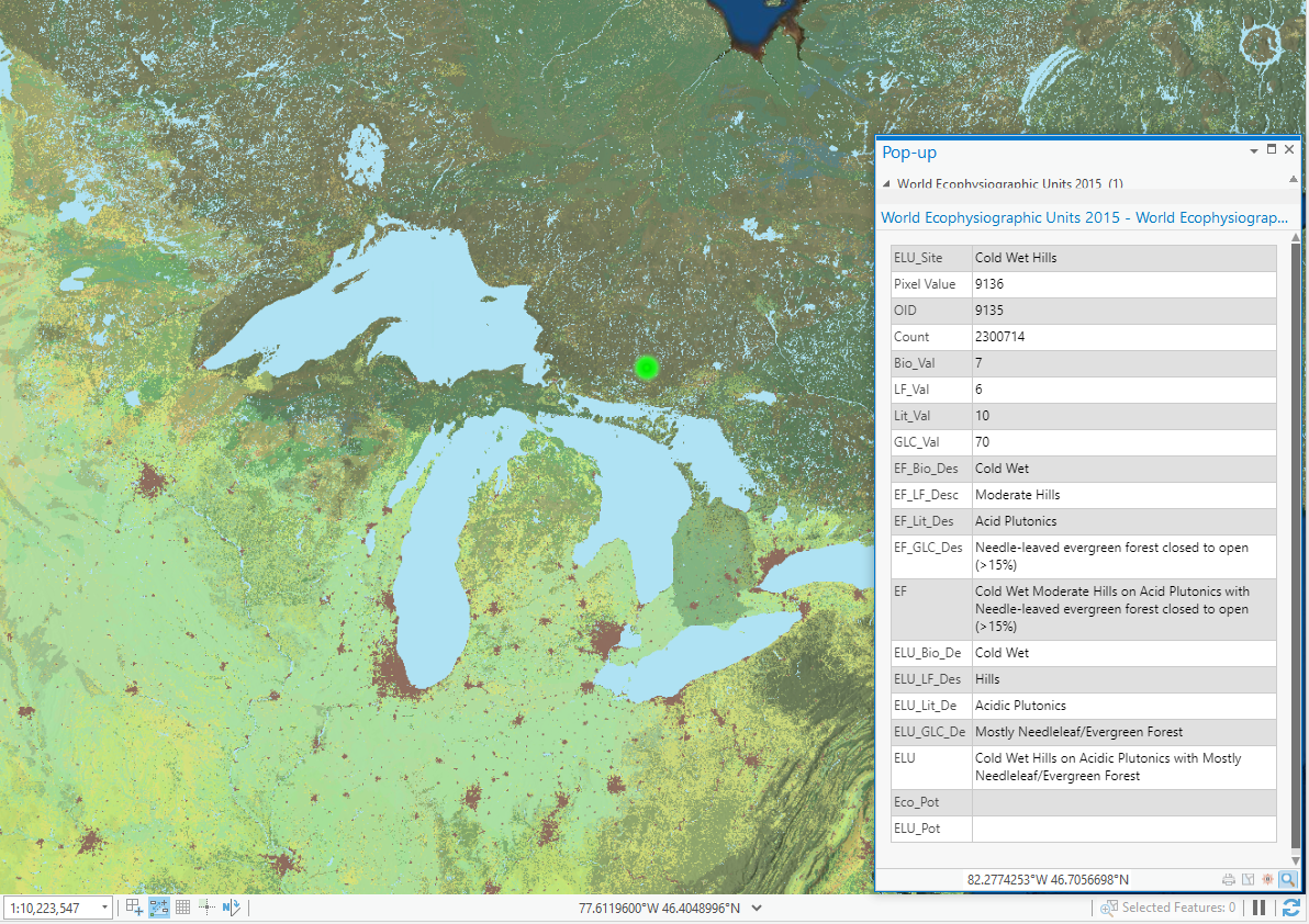
Sources: Esri, DigitalGlobe, GeoEye, i-cubed, USDA FSA, USGS, AEX, Getmapping, Aerogrid, IGN, IGP, swisstopo, and the GIS User Community
I mentioned the Gowganda Tillite and despite the wildly different eras of transportation, including the fact that my granite erratic may have moved before, after, or contemporaneously with the transportation which originally moved the tillite, that this tillite did land 450 miles more or less dead south from the parent formation. And I asked if taking all of that into consideration, was it reasonable to think that the granite erratic had originated north of the Gowganda Formation since the granite deposition was north of the tillite deposition. At this point I’m really pressing into my strategy of eliminating options to narrow down. What I want to know is if I can cut out everything in the Canadian Shield that occurs below the Gowganda Formation, and concentrate my efforts on looking north for likely parent rock.
Other clues are at hand: The rock has considerable weathering and if I was to use a descriptor of the sort I would use for roundness in sand, I would say it is somewhere between subrounded and rounded. There is also some contact midway through the stone that I'm not sure how to describe, it kind of looks like an intrusive dike, but the intrusive material appears to be very similar in composition to the country rock, although the grains in that intrusion are oriented at a 45 degree angle from the orientation of the grains in the country stone. Maybe this is another clue I could use when filtering regions by geomorphological trends to eliminate areas. The area for 200 miles north of Gowganda tends to be acid plutons and acid volcanics, and above that area up through James Bay/Moosonee and beyond tend to be metamorphics, so I also wonder if this supports the case for eliminating a band of area just north of the Gowganda Formation, and concentrate my search on areas up through James Bay and into the hard rock formations above the 61st parallel North. All of these details have some relationship to the answer I’m seeking. I realize correlation does not equal causation and that any one clue isn’t enough, but I also know enough about the entanglement of real life to know that when threads unravel you get to see how things were woven together. So thinking about my strategy of elimination, I’m going to be systematic about this. Which brings me back to the very obvious point that I can't do anything until I have a positive ID on my stone.
I ran all of this by Ralph and asked how he thinks I should proceed and he insists that I need isotope analysis and that I’d want “at the very least, Rb/Sr and Nd/Sm analysis, both stable and radiogenic to get an age and a plot of the two isotopic systems against each other. Zircon-based geochemistry and dating would be useful too.” So this is a request for help: If you work in a lab that can do this kind of analysis, and your lab wants to get involved with this project, drop me a line - I’d love to talk.
Long story short, stones from very far away have moved very long distances over very long periods of time, and it’s the opinion of several geologists that my stone did come from some portion of the Canadian Shield, but we won’t know where until I get some better data.