17. FIELD OFFICE WINTER UPDATE: 542 ERRATICS MAPPED
As of December, I was able to log a total of 542 glacially transported stones in the limestone quarry on Kelleys Island. I know that there are more stones along the outer edges of the quarry in the tree line surrounding the site, but my first goal was to log the stones within the area that had been quarried, and then to possibly expand to the margins.

screen shot of ArcGIS data layer of location of 542 glacial erratics in the quarry. service layer credit: Maxar. scale: 1:4,965
During this last mapping session, I logged nearly 300 stones, which was a surprise to me because the area covered in this last session represents less than 20% of the overall area of the quarry. This density, the patterns of distribution based on relative sizes, and the location of these caches of glacial stone have given me something to think about, and I'm beginning to run analysis algorithms on the data in my geographic information system database to see if I can make a definitive claim about the stones.
One thing I’ve learned that I wish I knew going into this project is that some of the spatial tools I’m trying to use need some specific additional data, so I’ll be collecting that additional data in the months to come. Initially, I was only interested in the metamorphic and igneous glacial stones (granites, quartzites, diorites, et cetera), but I came across several sedimentary stones that also showed evidence of glacial transportation (limestones in particular), so I recorded those as well.
I made a decision to not record any of the local limestone rocks because that was outside of the scope of what I was looking for, and this proved to be a mistake. Part of my initial hypothesis was that the glacial stones were discarded during quarrying operations. Halfway through the data collection (and after my comparative study of another regional quarry operated by the same workers during the same time period) it became clear that my hypothesis was probably wrong, it was most likely that the granite was being sorted and cached for collection.
In order to test this, one of the things I need to do now is look at the different spatial join matches that exist between the glacial stones and the rows of limestone piles throughout the quarry. The locations of glacial stones is a kind of point data, and I’ve been able to import that into my GIS as a feature class, but the rows of limestone piles are line data, and I don’t have that data recorded. Initially I was planning to use the satellite imagery as an overlay and trace the rows, but I’m having trouble getting the granularity of data that I want from the base map imagery and so I’m now going to grab that data by walking the piles in the field and tracking waypoints with my GPS so that I can import the data and populate the map with a feature class that has been ground-truthed.
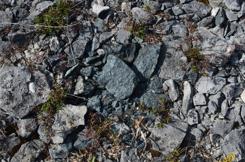
There was one stone that I found in the quarry during a scouting trip that I was unable to locate during my actual survey. It was a dark green granitic stone that had been fractured into a couple dozen shards. I have a photo of the stone from the scouting trip, but for whatever reason, I did not come across it again and it is a mystery to me. I'm going to look for it again in the spring.

flake 318 found in situ
I found a fragment of a different stone that I made a note of during my survey, and then several hours later in another part of the quarry I found the stone that this fragment came from. I confirmed this by retrieving the fragment and fitting it in place to the parent stone, and then I returned the fragment to the location where I originally found it. This incident confirmed for me the scale of human movement of these igneous stones within the limestone quarry.

will it fit?

flake 318 and boulder 346 are a perfect match
Another stone that I keep track of was moved a significant distance this summer by visitors to the quarry who had built a spiral cairn of limestone and put the granite boulder at the center of the gyre. They moved this stone 120 feet from where I had last seen it, and the stone weighs about 250 pounds, so moving it was a difficult task for whoever built the cairn. I was able to move it back to the recorded location, and I look forward to seeing if it moves again.

Most of you know about my project This Stone Wants To Go Home, in which I am mounting an expedition to return a granite boulder to the remnant of the glacier that originally moved it during the last ice age. I've been thinking about these human movements of stone in the quarry during my last few trips to the island, considering how my act of moving a boulder fits into this context as a similar sort of human action. These quarry-sorting and removal operations and my attempt to reunite a boulder to the landscape where it originated are both examples of the human movement of stone, and they are both examples of human activity defying the geologic. I'm hoping mine is more poetic since I'm actually engaging the source glacier and doing the work to recognize the marks and traces this glacier made in the deep past. My project is a dialogue with deep time where I'm asking the glacier to move the same stone again during the next ice age (if it ever comes).
I mention this expedition because while I was building the map of the quarry and entering the locations of these 542 glacial stones in my database, I couldn't help but imagine what will happen to these geologically classified "hard-rock" stones during the next glaciation, when they are picked up and pushed across the soft sedimentary limestone landscape again.
Kelleys Island is known for a series of glacial grooves that were formed by these very stones that are scattered across the island, and historic photos of the island show that many of these quarried areas actually had massive glacial grooves carved in the limestone that was quarried away for gravel and building materials.
These stones that shaped this landscape might get a chance to do it again in the next ice age, and so I'm working on simulations of the data to specify what a future landscape of the quarry might look like after the next glaciation. The size of the stones, the hardness of the stones with respect to the hardness of the bedrock, their location, and sequenced distribution all make it possible to speculate about how these stones will become cutting tools for a future glacier in the deep deep future. This is in line with a couple of earlier projects of mine (Implements For Future Glacial Scouring, 2015; and Lines Of Descent, 2019) where I modeled landscapes and formulated a design language for priming landscapes for future collaboration with geologic forces of the next ice age.

installation view from Lines of Descent (2019), The Sculpture Center, Cleveland, Ohio. on the table are hand tools fitted with blades in the shape of granite tombstones and landscape models that show how a glacier would shape the landscape by grinding tombstones across the ground during the next ice age.
I'm hoping to talk more about this with you later this year as I turn my attention in my field work away from the quarry so that I can look more closely at the glacial morphology of the island and the various glacial grooves that remain across the island. I'll be sharing some of the ways my studio practice has been impacted by what I've learned so far from these grooves and I may share some process videos on my website as I further develop a body of work that has emerged during this project. I feel like I need to get a little further along before I share this online though.
Ferry service is spotty in the winter months and will at some point shut down for the season, so I'll need to charter a plane for some of my winter trips which I'm very excited about because I'll be able to take some aerial photographs of the areas where I've been working. I'm hopeful that I'll also be able to see the glacial grooves covered in snow, which is something I've never been able to see before. I might not be able to land on the island every month during the winter, but it is my intent to get as close as I can. I’m still sending postcards to my archive at the Nevada Museum of Art and to my subscribers, and when I can’t land on the island, I’ll send those from post offices along the western basin of Lake Erie.
Speaking of my postcards, I’ve printed another boxed edition of commemorative photos and I’ll be releasing those on my site sometime before March. It’s an edition of 18, which includes a set for my archive, and two artists proofs, so in reality there will only be 15 available for purchase. I’ll be announcing those boxed sets through my newsletter, so please be sure to subscribe.
Thanks for reading, and thanks for your support. Happy New Year.